OSIRIS
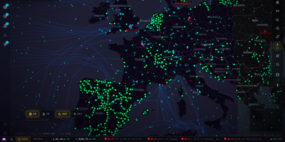
Plotting live flights, earthquakes, wildfires, satellites, and news streams on one night-mode map, OSIRIS gives open-source intelligence work a single browser tab to live in. Sixteen layers toggle on and off with live entity counts. Aviation covers commercial, private, and military traffic. Ports and chokepoints, severe weather, space weather, and 15 hand-curated conflict zones get layers too. More than 17,000 public cameras open in a viewer when you click a pin. Draw a region, list every camera inside it, and export the set as GeoJSON. Twenty-three live news streams open from dots on the map. Double right-click anywhere for a Region Dossier with the place, country facts, head of state, and a Wikipedia summary. A Markets terminal follows indices, stocks, oil, commodities, currencies, and crypto, with a watchlist. Live Alerts sorts headlines, warnings, and quakes into searchable tabs. The Recon toolkit runs DNS, WHOIS, certificate, and subdomain lookups, searches the OFAC sanctions list, and traces BTC and ETH wallets. OI, the built-in assistant, flies the map to a place and switches layers on from typed or spoken requests. Its Forecast mode plays competing actors against each other in parallel simulated worlds and writes a sourced prediction on your own model key. Six preset themes restyle the whole interface. Running on a dedicated VPS on RepoCloud with guaranteed CPU, RAM, and SSD, full root SSH access, and a browser serial console. MIT licensed.
AirTrail
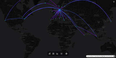
Commercial flight logbooks frequently lock historical travel records behind annual subscriptions or shut down unexpectedly, whereas AirTrail preserves your complete aviation history on an interactive world map under your own control. Enter a flight number to look up routes automatically or log departures manually with seat numbers, cabin classes, aircraft registrations, timestamps, notes, and custom metadata fields. Switching from another tracker takes seconds: the built-in importer ingests CSV, ICS, and JSON exports from MyFlightradar24, Flighty, App in the Air, OpenFlights, TripIt, JetLog, byAir, and JetLovers. The vector map renders geodesic flight paths, recorded GPS tracks, and airport runway details across customizable basemaps. Detailed statistics dashboards break down total distance flown, time in the air, top airlines, aircraft models, and visited countries. Families and travel groups can share a single instance with role-based permissions, OAuth single sign-on, and read-only public links, while developers automate entries through the versioned REST API or Model Context Protocol server. Running on a dedicated VPS on RepoCloud with guaranteed CPU, RAM, and SSD, full root SSH access, and a browser serial console. GPL-3.0 licensed.