Dawarich Atlas
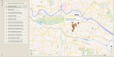
Atlas turns OpenStreetMap data for a city, a country, or the whole planet into a maps backend your applications can search, route with, and query for nearby places, all on hardware you control: pick a region and it downloads and indexes that territory's data locally. Search behaves the way users expect, with autocomplete matches grouped into clusters across the installed dataset, numbered so dense areas stay readable, and a show-all action that frames the full result set. Routing returns directions for driving, cycling, and walking, and a map-matching endpoint snaps noisy recorded GPS tracks onto the real road network. Ask what is here at any coordinate and category pickers surface restaurants, stations, parking, and hundreds of other place types around it, while transit planning threads timetables into door-to-door journeys. The settings panel is the control room: toggle search, routing, points of interest, and transit independently, switch the active region, and watch live progress as new territory is ingested and merged in the background. Developers plug in through one consistent JSON API covering geocoding, reverse geocoding in batches, coverage checks, and every map capability, documented as a public OpenAPI reference. Because every dataset lives on the box, the map keeps answering during outages and inside private networks. Running on a dedicated VPS on RepoCloud with guaranteed CPU, RAM, and SSD, full root SSH access, and a browser serial console. AGPL-3.0 licensed.
Deploy