Google Maps Scraper
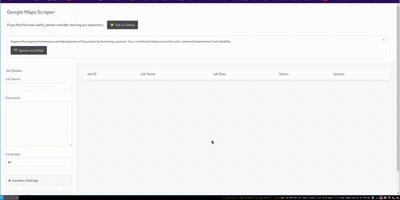
The leading open-source tool for extracting business leads from Google Maps at production scale. The Go-based engine processes approximately 120 places per minute with optimized concurrency, extracting 33+ data points per listing including business name, address, phone number, website URL, rating, review count, latitude and longitude, opening hours, price level, and optionally crawling business websites for email addresses. Three interfaces serve different workflows: the CLI accepts query files for cron jobs and CI/CD pipelines with output to CSV, JSON, PostgreSQL, S3, or LeadsDB; the Web UI provides a browser-based dashboard with real-time job monitoring, a map view of scraped places, and interactive query submission; and the REST API at /api/v1 enables programmatic integration with full Swagger documentation at /api/docs. Built-in proxy rotation supports SOCKS5, HTTP, and HTTPS with authentication for large-scale runs, while the architecture scales from a laptop to Kubernetes clusters with queue-based worker distribution. The SaaS edition adds multi-user access with API key management, admin UI with 2FA, job queue orchestration, and one-command cloud deployment via an interactive wizard. An AI Agent Skill enables coding agents to run scrapes programmatically. Deploy via Docker or build from source requiring Go 1.26.5+. Running on a dedicated VPS on RepoCloud with guaranteed CPU, RAM, and SSD, full root SSH access, and a browser serial console. MIT licensed.
Dawarich
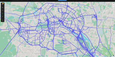
With over 9,000 GitHub stars earned since Google killed its browser-based Timeline, Dawarich fills the gap with a fully self-hosted location history platform that keeps your movement data under your control. Built on Ruby on Rails 8.0 with PostgreSQL and the PostGIS spatial extension for geometry-based queries, Dawarich imports your entire Google Takeout location archive in minutes and begins rendering interactive maps immediately. The visualization engine supports five map layers — heatmaps, points, lines, Fog of War exploration tracking, and a 3D globe view — each powered by Leaflet and spatial SQL rather than browser-side computation. Native iOS and Android apps handle background GPS tracking with offline support, automatically uploading location points when connectivity returns, while third-party integrations support OwnTracks, GPSLogger, Overland, Home Assistant, Traccar, and PhoneTrack. The trip system lets you create route visualizations between any two dates, attach notes, replay travel paths with a timeline scrubber, and share trips publicly with phrase-protected links and per-section visibility controls. Immich and PhotoPrism integrations automatically overlay geotagged photos on your maps and trips, while AirTrail integration renders flight history as arcs. Statistics dashboards break down countries visited, cities explored, total distance traveled, and active days by year and month, with visit detection suggesting places you have frequented. Running on a dedicated VPS on RepoCloud with guaranteed CPU, RAM, and SSD, full root SSH access, and a browser serial console. AGPL-3.0 licensed.
AdventureLog
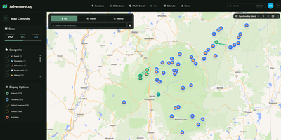
AdventureLog tracks and visualizes your travels on an interactive world map, combining GPS-tagged location logging with collaborative trip planning and a personal atlas that fills in as you explore new countries and regions. The SvelteKit frontend renders lightning-fast interactive maps powered by MapLibre GL, displaying every logged location with filtering by visit status, custom categories, and a stunning 3D globe view for immersive exploration. Each adventure entry stores rich metadata including precise GPS coordinates via PostGIS, visit dates, personal ratings, descriptions, photos, and trail uploads with detailed activity statistics. The multi-day itinerary planner organizes trips with flight information, daily activity schedules, packing checklists, collaborative notes, and resource links, while real-time sharing lets travel companions view and edit plans together. The world travel book automatically tracks which countries, states, and regions you have visited, rendering them on interactive choropleth maps that grow with every journey. Native integration with Immich connects your photo library directly, allowing photo imports via API key authentication and smart search. Django AllAuth handles user authentication with social login support, and the Django REST Framework API enables third-party integrations and mobile app connectivity. The project has gathered over 3,500 GitHub stars since its 2024 launch. A single Docker container bundles frontend, backend, and Nginx on one port for straightforward deployment. Running on a dedicated VPS on RepoCloud with guaranteed CPU, RAM, and SSD, full root SSH access, and a browser serial console. GPL-3.0 licensed.
TREK
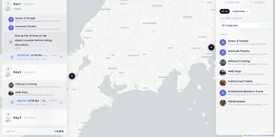
TREK coordinates group expeditions and vacations through a collaborative travel planning workspace that unifies daily itineraries, interactive route maps, shared expense budgets, and packing lists. Travel groups can build day-by-day timelines by dragging activities between dates, attaching transit bookings with flight numbers, and estimating driving intervals directly on OpenStreetMap and Mapbox canvases. Instant WebSocket synchronization mirrors itinerary edits, group chat messages, and decision poll votes across all traveling companions simultaneously without page refreshes. The integrated multi-currency expense manager tracks shared expenditures across lodging, dining, and transit categories, automatically calculating per-person debts and generating simplified debt settlement summaries. An interactive world atlas highlights visited nations and tracks lifetime travel statistics, enabling globe-trotters to manage personal bucket lists and review past journeys. Travelers can organize shared packing checklists from reusable equipment templates, monitor real-time weather forecasts powered by Open-Meteo, and export comprehensive travel schedules to printable PDF guides and calendar feeds. Role-based permission controls safeguard sensitive travel documents and boarding pass uploads while allowing guests to contribute notes and vote on activities. Running on a dedicated VPS on RepoCloud with guaranteed CPU, RAM, and SSD, full root SSH access, and a browser serial console. AGPL-3.0 licensed.

Wanderer
Wanderer provides a privacy-first alternative to AllTrails and Komoot, giving outdoor enthusiasts complete ownership of their GPS data on a self-hosted server. The platform accepts uploads in GPX, KML, FIT, and TCX formats, automatically extracting distance, elevation gain and loss, duration, and speed statistics to build a searchable trail catalogue. The built-in route planner uses the Valhalla routing engine to calculate hiking, cycling, and walking routes directly on the map, while MapLibre GL renders smooth vector tiles from OpenStreetMap data with configurable tile sources and overlay layers. Each trail supports rich metadata including difficulty ratings, categories, waypoints with descriptions, photo galleries, and summit log entries that track completion dates with optional GPS data. Meilisearch powers instant full-text search across trail names, descriptions, and tags, complemented by map-based spatial filtering and advanced date, distance, and elevation filters. The ActivityPub integration follows the same federation protocol as Mastodon, allowing users to follow explorers on other Wanderer instances and see their public trails, comments, and summit logs in a unified feed without requiring cross-instance accounts. The WASM-based plugin system enables third-party extensions for custom integrations. The Docker Compose stack runs three containers — SvelteKit frontend on port 3000, PocketBase backend with embedded SQLite, and Meilisearch — with startup completing in under 90 seconds. On RepoCloud, deploy Wanderer on a dedicated VPS with root SSH access, persistent storage for your trail database and uploaded photos, and complete control over routing, geocoding, and tile server configurations, all under the AGPL v3 license.