GeoLens
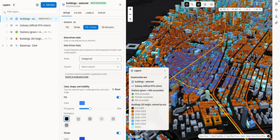
Transforming scattered spatial files into an interactive data catalog, GeoLens empowers engineering and GIS teams to organize geospatial assets, execute semantic searches, and build interactive 3D maps on self-hosted infrastructure. Users can ingest shapefiles, GeoJSON boundaries, database tables, and Cloud-Optimized GeoTIFF rasters into a centralized inventory with automatic source freshness auditing. Natural language queries evaluate dataset relevance across spatial boundaries and thematic tags, allowing analysts to uncover hydrology networks or zoning footprints without knowing exact layer names. The browser-based composition canvas lets cartographers extrude three-dimensional building footprints, overlay elevation terrain contours, color features by attribute values, and reorder layer hierarchies with drag-and-drop ease. Finished map projects publish immediately as secure shareable web links or responsive embeds for external dashboards. Desktop GIS operators can connect directly from QGIS or ArcGIS through native OGC API Features and STAC endpoints to query live vector tiles and run spatial filters. Teams can export filtered geometries into GeoPackage, FlatGeobuf, GeoParquet, or PMTiles archives to support downstream analysis workflows. Running on a dedicated VPS on RepoCloud with guaranteed CPU, RAM, and SSD, full root SSH access, and a browser serial console. Apache 2.0 licensed.
NextGIS Web
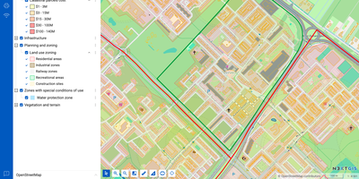
NextGIS Web turns shapefiles, GeoTIFFs, and QGIS projects into shareable web maps on your own server, with no per-seat GIS license to buy. Upload ESRI Shapefile, GeoJSON, GeoPackage, KML, CSV, or GeoTIFF files, or connect an external PostGIS database, then style layers with QGIS styles so web maps match the desktop project. Visitors can search, filter, measure, print, and embed maps on other sites, while editors draw or move points, lines, and polygons, type in coordinates, and snap to existing geometry without leaving the browser. Vector layers keep a history of who changed what and when, so a bad edit can be rolled back and a snapshot of the data at a chosen point in time can be recovered. Layers can be published as WMS, WMTS, WFS, OGC API Features, raster tiles, vector tiles, or Cloud Optimized GeoTIFF, and third-party TMS, WMS, and WFS services can be pulled into the same maps. With the NextGIS Connect plugin, QGIS users publish projects and edit server data directly, so a whole team works on one shared dataset. Permissions are granted to users and groups down to a single layer or map, and Galleries collect the key maps into one landing page. A REST API covers users, layers, services, maps, and permissions, and JavaScript libraries help developers build custom map applications. Running on a dedicated VPS on RepoCloud with guaranteed CPU, RAM, and SSD, full root SSH access, and a browser serial console. GPL-3.0 licensed.